Elevations and Locations
Tahari
The Mapping of Gor is generating one map in 3-D as of this date that has 45,000 individual data points. The first image shows you those data points. Since the data points are so closely located, the map is now beginning to look like a regular planar map - though it is not. From these points the landscape of Gor is generated. The second image provides a glimpse of the landscape and the terrain elevations. As the number of data points increase, the level of detail increases.
This series covers the Tahari Region of Gor. As far as I know it has never been mapped like this. Current existing maps show the desert location incorrectly and the places within the desert incorrectly - according to the chronicles of Gor.
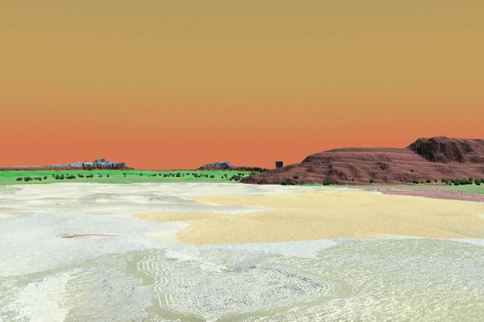
This series shows the 'new' location of the Tahari Desert.
In the Tahari there is an almost constant wind.
It is a hot wind, but the nomads and the men who ply the Tahari welcome
it. Without it, the desert would be almost unbearable, even to those with
water and whose bodies are shielded from the sun. I listened to the caravan
bells, which sound is pleasing. The kaiila moved slowly. Prevailingly,
the wind in the Tahari blows from the north or northwest. There is little
to fear from it, except, in the spring, should it rise and shift to the
east, or, in the fall, should it blow westward.
We were moving through hilly country, with much scrub brush. There were
many large rocks strewn about. Underfoot there was much dust and gravel.
On the shaded sides of some rocks, and the shaded slopes of hills, here
and there, grew stubborn, brownish patches of verr grass. Occasionally
we passed a water hole, and the tents of nomads. About some of these water
holes there were a dozen or so small trees, flahdah trees, like flat-topped
umbrellas on crooked sticks, not more than twenty feet high; they are
narrow branched, with lanceolate leaves. About the water, little more
than muddy, shallow ponds, save for the flahdahs, nothing grew; only dried,
cracked earth, whitish and buckled, for a radius of more than a quarter
.of a pasang, could be found; what vegetation there might have been had
been grazed off, even to the roots; one could place one’s hand in
the cracks in the earth; each crack adjoins others to constitute an extensive
reticulated pattern; each square in this pattern is shallowly concave.
The nomads, when camping at a watering place, commonly pitch their tent
near a tree; this affords them shade; also they place and hang goods in
the branches of the tree, using it for storage. Tribesman of Gor Pg 71
The Tahari Desert is said to be hundreds of pasangs wide and thousands of pasangs long. More specifically, it is described as being trapeziod in shape.
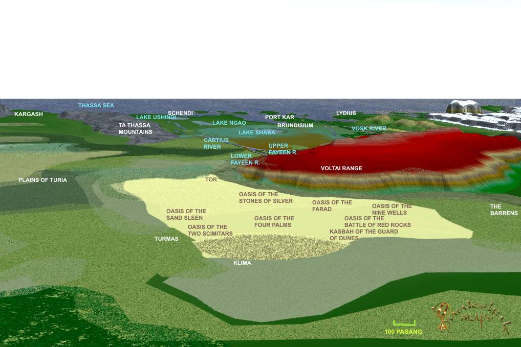
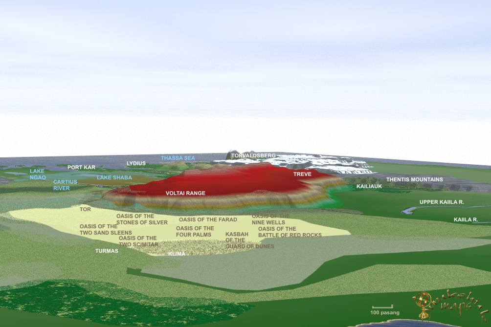
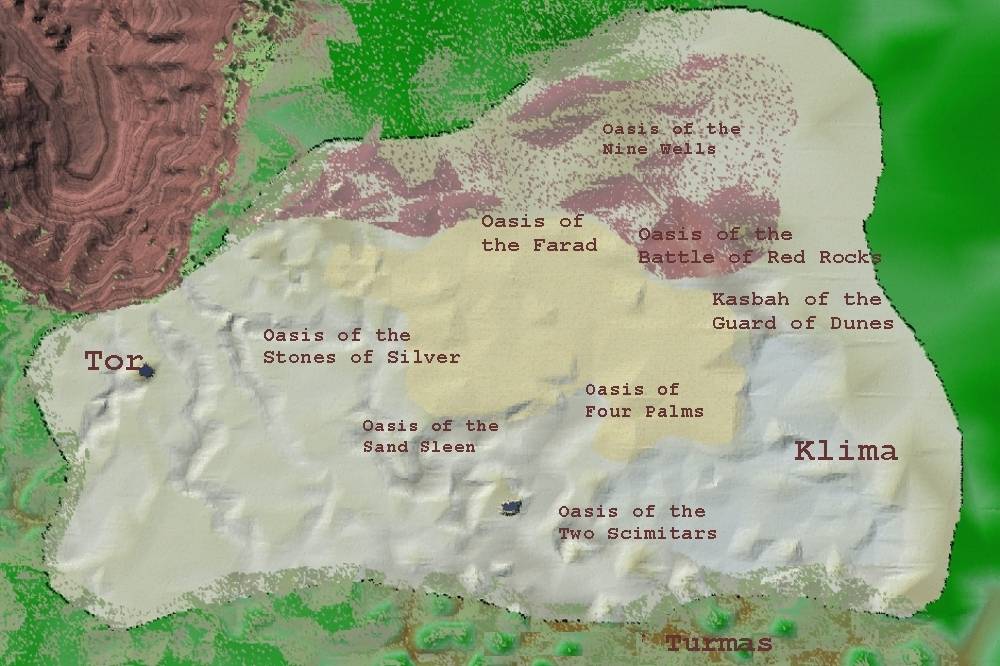
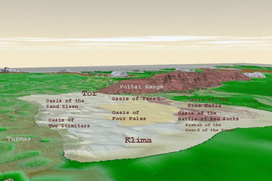
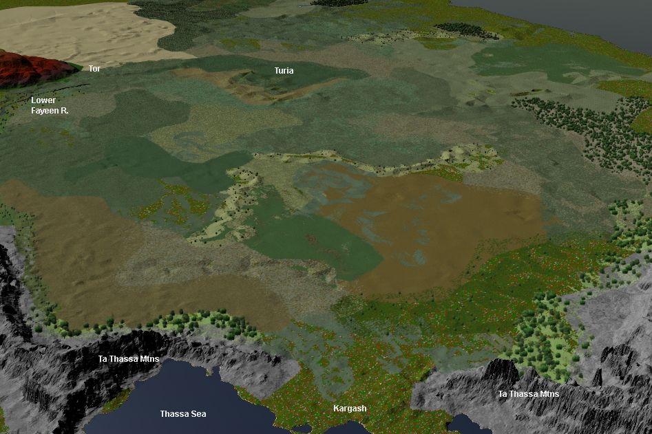
It is located south of the Voltai Range, and east of AR. A dry place, out of the way and huge in size, the most northwesterly city is Tor. The most southeasterly is Klima - famed for the salt mines. The land is hilly and rocky. There are many Oasis and I have made that area near the Oasis of the Battle of Red Rocks show red rocks. Another confusing aspect up until now in some maps has been the location of Turmas. In fact, they do not lie in the desert, but are a Turian outpost that borders the desert.
In the distance, below, perhaps five pasangs
away, in the hot, concave, white salt bleakness, like a vast, white, shallow
bowl, pasangs wide, there were compounds, low, white buildings of mud
brick, plastered. There were many of them. They were hard to see in the
distance, in the light, but I could make them out. "Klima,"
said Hamid.
Tribesmen of Gor Pg 235
"The principal export of the oases are
dates, or pressed-date bricks." Tribesmen of Gor Pg 37
"He might as well have used Tor, which is an oasis city in the deserts
far below Ar, and to its east".
Hunters of Gor Pg 43
I looked downward. Though on the map it occupied
only some several feet of the floor, in actuality it was vast. It was
roughly in the shape of a gigantic, lengthy trapezoid. Even in the reduced
scale of the map the desert seemed vast. Its mere representation, as earlier
indicated, covered several square feet of the floor. It was roughly in
the shape of a gigantic, lengthy trapezoid, with eastward leaning sides.
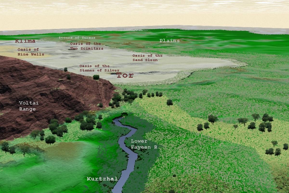
At its northwestern corner lay Tor. West of Tor, on the Lower Fayeen,
a sluggish, meandering tributary, like the Upper Fayeen, to the Cartius,
lay the river port of Kasra, known for its export of salt.
The area, in extent, east of Tor,
was hundreds of pasangs in depth, and perhaps thousands in length. The
Gorean expression for this area simply means the Wastes, or the Emptiness.
It is a vast area, and generally rocky, and hilly, save in the dune country.
It is almost constantly windblown and almost waterless. In areas it has
been centuries between rains. Its oases are fed from underground rivers
flowing southeastward from the Voltai slopes.
Tribesmen of Gor Pg 32
This was an oasis of the Char, also a vassal
tribe of the Kavars. Its name had been given to it centuries before, when
thirsty men, who had moved at night on the desert, had come upon it, discovering
it. Tribesmen of Gor Pg 105
The oasis of Two Scimitars is an out-of-the-way oasis, under the hegemony
of the Bakahs, which, for more than two hundred years, following their
defeat in the Silk War of 8,110 C.A., has been a vassal tribe of the Kavars.
Tribesmen of Gor Pg 151
"I was later sold in Tor," she said, "far to the north
of Turia.
Assassin of Gor Pg 47
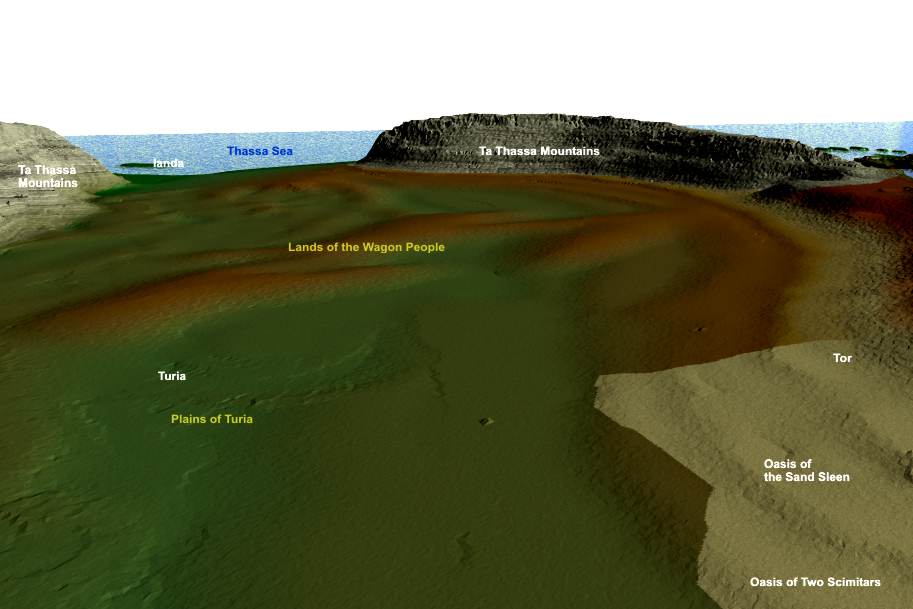
Looking from the souteast edge of the Tahari provides an understanding about just how big the desert is - and just how remote Klima actually is. For this mapping I have included the 'dunes' area which is lighter yellowish color. To travel from Tor to Turmas one would go east then south, or south then east, avoiding the dunes. The reddish patches arouund the Oasis of the Battle of Red Rock are visible. I would estimate, that the distance from the Stones of Turmas to Turia is perhaps 1500 or more pasang. I will deal with that later when I start mapping the Plains. Looking from a Perspective near Tor, the Lower Fayeen River is seen before it ends. Tor is considered a crossroads in Gor. It is near the Salt Line and also via the Lower Fayeen one can travel to the Cartius. It is remote though.
Tor, lying at the northwest corner of the Tahari,
is the principal supplying point for the scattered oasis communities of
that dry vastness. These communities, sometimes quite large, numbering
in the hundreds, sometimes thousands of citizens, depending on the water
available, are often hundreds of passangs apart. they depend on caravans,
usually from Tor, sometimes from Kasra, sometimes even from far Turia,
to supply many of there needs. In turn, of course, caravans export the
products of the oases. To the oases caravans bring various goods, for
example, rep cloth, embroidered cloths, silks, rugs, silver, gold, jewelry's,
mirrors, kailiauk tusk, perfumes, hides, skins, feathers, precious woods,
tools, needles, worked leather goods, salt, nuts and spices, jungle birds,
prized as pets, weapons, rough woods, sheets of tin and copper, the tea
of Bazi, wool from the bounding Hurt, decorated, beaded whips, female
slaves, and many other forms of merchandise. the principal export from
the oases are dates and pressed date bricks. some of the date palms grow
to more than a hundred feet high. It takes ten years before they begin
to bear fruit. They will then yield fruit for more than a century. A given
tree, annually, yields between one and five Gorean weights of fruit. A
Gorean weight is some ten stone or forty earth pounds. A great amount
of farming, or perhaps one should say gardening, is done at the oasis,
but little of this is exported. At the oasis is grown a hybrid, brownish
Sa-Tarna, adapted to the heat of the desert; most Sa-Tarna is yellow;
and beans, berries, onions, tuber suls, various sorts of melons, a foliated
leaf vegetable, called Katch, and various root vegetables, such as turnips,
carrots, radishes, of the sphere and cylinder varieties, and korts, a
large, brownish skinned, sphere shaped vegetable, usually some six inches
in width, the interior of which is yellow, fibrous and heavily seeded.
At the oasis, because of the warm climate, the farmers can grow two or
more crops a year. Larma and tospits are also grown at the oases, in small
orchards. Some rep is grown, for cloth, but most cloth come to the oases
from caravans. Kaiila and verr are found at the oases, but not in large
numbers. The herds of these animals are found in the desert. They are
kept by the nomads, who move them from one area of verr grass to another,
or from one water hole to another, as the holes, for the season, go dry.
Smaller water sources are used in the spring, for these are the first
to go dry, larger ones later in the year. No grass grows about these water
holes because animals are brought to them and graze it to the earth. they
are usually muddy ponds, with some stunted trees about, centered in the
midst of an extensive radius of grass less, cracked, dry, earth. Meat,
hides, and animal hair cloth are furnished to the oases by the nomads.
In turn, from the oases the nomads receive, most importantly, Sa-Tarna
grain and Bazi tea. they receive, as well of course, other trade goods.
Sa-Tarna is the main staple of the nomads. They, in spite of raising herds,
eat very little meat. The animals are too precious for their trade value,
and their hair and milk, to be often slaughtered for food. A nomad boy
of fifteen will often have eaten meat no more than a dozen times in his
life. Raiders, however, feast well on meat. The animals mean little to
them and come to them cheaply. Tea is extremely important to the nomads.
It is served hot and heavily sugared. It gives them strength then, in
virtue of the sugar, and cools them, by making them sweat, as well as
stimulating them. It is drunk in three small cups at a time carefully
measured.
From Tribesmen of Gor Pg 38
Caravans with goods tend to travel the western,
or distant eastern edge of the Tahari; caravans do, it might be mentioned,
occasionally travel from Tor or Kasra to Turmas, a Turian outpost and
kasbah, in the southeastern edge of the Tahari, but even these commonly
avoid the dune country, either moving south, then east, or east, then
south, skirting the sands. Few men, without good reason, enter the dune
country. Tribesmen of Gor Pg 179
The purple flowers in all these images are 'desert verminium' - drawn by an artist. Her name is ka'reena (AoA) and she does mighty fine work. I take the drawings then locate and 'grow' plants across the ecosystems. She is drawing others which you will see throughout this series.
The march of Hassan had as its object not Red
Rock, northwest of Klima, but Four Palms, a Kavar outpost known to him,
which lay far to the south of Red Rock. Unfortunately Four Palms was farther
from Klima than Red Rock. On the other hand, his decision seemed to me
a sound one. Red Rock was a Tashid oasis under the hegemony of the Aretai,
enemies of the Kavars. Furthermore, between Klima and Red Rock lay the
regions patrolled by the men of Abdul, the Salt Ubar, who had been known
to me as Ibn Saran..
Tribesmen of Gor Pg 270-271
Because of the irregular topography of Tor, however, which is a hilly, rocky, area, like most of the Tahari terrain, many of the buildings, built on shelves and rises, seemed considerably higher. These buyildings, on the outside smooth and bleak, save for the occasional narrow windows, high, not wide enough to admit a body, abut directly to the streets, making the streets like deep, walled alleys. In the center of the street is a gutter. It seldom rains in Tor, but the gutter serves to collect waiste, which is often thrown into it, through open doors, by slaves. Within these walls, however, so pressing upon the street, I knew there were often Gardens, walled, well watered, beautiful, and cool, dark rooms, shielded from the heat and sun, many with superb appointments. Tor was, as Gorean cities went, a rich, trading city. It was headquarters for thousands of caravan Merchants. In it, too, were housed many craftsmen, practicing their industries, carvers, varnishers, table makers, gem cutters, jewelers, carders, dyers of cloth, weavers of rugs, tanners, makers of slippers, toolers of leather, potters, glaziers, makers of cups and kettles, weapon smiths, and many others. Much of the city, of course, was organized to support the caravan trade. there were many walled, and gaurded, warehouses, requireing their staffs of scribes and guards, and, in hundreds of hovels, lived kaiila tenders, drovers and such, who would, at the caravan tables, when their moneys had been exhausted, apply, if accepted, making their mark on the roster, once more for a post on some new caravan. Gaurds for these caravans, incidentally, where usually known by, and retained by, caravan merchantsbetween caravans. They were known men.
From Tribesmen of Gor Pg 39

Tribesmen of Gor Pg 238
The secretly located Kasbah of the Salt Ubar, highest in the salt trade of the Tahari, is said to be somewhere east of the Oasis of the Battle of Red Rock and northwest of Klima. "It can be only," said Hassan, "the kasbah of the Guard of the Dunes." "That of the Salt Ubar?" I asked. "That," agreed Hassan. I had heard of the Salt Ubar, or the Guard of the Dunes. The location of his kasbah is secret. Probably, other than his own men, only some few hundred know of it, primarily merchants high in the salt trade, and few of them would know its exact location. Tribesmen of Gor Pg 207
"I was mildly surprised that the boy had been eating the tospit raw, for they are quite bitter, but, I knew, that the people of the Tahari regions, these bright, hot regions, relished strong tastes and smells. Some of the peppers and spices, relished even by children in the Tahari districts, were sufficient to convince an average good fellow of Thentis or AR. that the roof of his mouth and his tongue were being torn out of his head." Tribesmen of Go Pg 46
On foot, on the trail, they would have only
enough water to reach the tiny oasis of Lame Kaiila, where there would
be for them doubtless sympathy, but little aid in the form of armed men.
Indeed, it lay in a direction away from Nine Wells, which was the largest,
nearest oasis where soldiers might be found. By the time word of the raid
reached Nine Wells the raiders might be thousands of pasangs away.
Tribesmen of Gor Pg 136
"...Merchants will not care to risk their
goods. It is their intention that Suleiman not receive these goods. It
is their intention to divert them, or most of them, to the Oasis of the
Stones of Silver." This was an oasis of the Char, also a vassal tribe
of the Kavars. Its name had been given to it centuries before, when thirsty
men, who had moved at night on the desert, had come upon it, discovering
it. Dew had formed on the large flat stones thereabouts and, in the light
of the dawn, had made them, from a distance, seem to glint like silver....
Tribesmen of Gor Pg 93-94
The oasis of Two Scimitars is an out-of-the-way oasis, under the hegemony
of the Bakahs, which, for more than two hundred years, following their
defeat in the Silk War of 8,110 C.A., has been a vassal tribe of the Kavars....
Tribesmen of Gor Pg 151

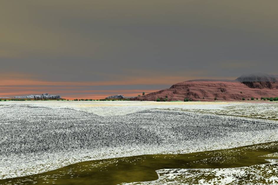
This image is looking to the northwest from a point
just beyond Klima, in the Tahari along the south east edge. You can see
my beginnings of an open pit salt mine - it is terraced and it is deep.
|And it is in the middle of nowhere - pity those males who dredged in
this forgotten place.
The bottom image is inside the salt mine - well almost. The dunes can be seen behind.
To my right were the lines of the Aretai. The Aretai themselves, of course, with black kaffiyeh and white agal cording, held their center. Their right flank was held by the Luraz and the Tashid. Their left flank was held by the Raviri, and four minor tribes, the Ti, the Zevar, the Arani and the Tajuks. The Tajuks are not actually a vassal tribe of the Aretai, though they ride with them. More than two hundred years ago a wandering Tajuk had been rescued in the desert by Aretai riders, who had treated him well, and had given him water and a kaiila. The man had found his way back to his own tents. Since that time the Tajuks had, whenever they heard the Aretai were gathering, and summoning tribes, come to ride with them. They had never been summoned by the Aretai, who had no right to do this, but they had never failed to come. Tribesman of Gor Pg 301
"I extended my hand to Ibn Saran and he,
bowing twice, brushed twice the palm of his hand against mine. 'May you
always have water, may your water bags never be empty.' " Tribesmen
of Gor Pg 21
This was irritating to Hassan, and did not much
please me either, for the oasis of the Battle of Red Rock was the last
of the major oases of the Tahari for more than two thousand pasangs eastward;
it lay, in effect, on the borders of the dreaded dune country; there are
oases in the dune country but they are small and infrequent, and often
lie more than two hundred pasangs apart; in the sands they are not always
easy to find; among the dunes one can, unknowingly, pass within ten pasangs
of an oasis, missing it entirely....
Tribesmen of Gor Pg 179
My thanks to 'autumn NS' for her help in this. This woman knows her books and makes my work easier.
As well I wish to thank Karnik, ARES, riella 'X'
and ka'reena (AoA) for her great creative artwork.
And Tazmin - just because.
Right click 'Save' for the larger images.
Inukshuk - 2002 - 2004 and forever